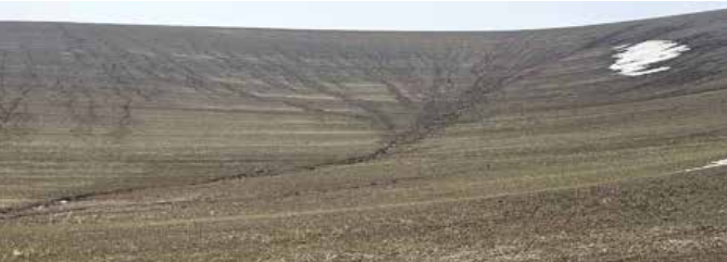
Abrupt transitions from snow to mud are a common phenomenon for spring on the Palouse. Unfortunately, when high volumes of water run overland, soil often moves with it. The most hazardous situation for soil loss is when warm temperatures that melt snow and thaw the top inch or more of frozen soil are accompanied by rain. Here, water that cannot infiltrate the underlying frozen soil runs over the surface carrying valuable topsoil and agrichemicals with it. This is a selective process as soil organic matter and clay particles are more easily transported down the slope.
Much is lost when water and topsoil move downslope. In addition to reducing soil water recharge, the loss of topsoil results in nutrient loss and reduces the soil’s future capacity to store water, thereby limiting crop yield potential. Furthermore, when nutrients and agrichemicals leave the field along with soil, a valuable resource becomes a challenge.
Soil erosion is typically characterized by three categories: water, wind, and displacement (such as results in movement downhill with tillage). In many cases, soil erosion can be reduced using best practices for soil health. Often, Mother Nature is blamed for the amount of soil destruction that can occur when rain, melting snow, and partially thawed ground results in serious soil erosion.
Management practices can mitigate or even eliminate soil erosion when adverse conditions arise.
The Revised Universal Soil Loss Equation (RUSLE2) from the U.S. Department of Agriculture’s Agricultural Research Service (USDA-ARS) calculates soil erosion with a combination of soil type/vulnerability of loss, land use such as cover management, and topography — including slope length, steepness, and shape.
Approaches to minimize water erosion utilize practices that increase water infiltration and enhance soil water storage (holding capacity). These practices include:
- Reducing soil disturbance.
- Maintaining soil cover.
- Maintaining living roots.
- Increasing soil organic matter.
- Reducing compaction and improving soil structure to enhance water infiltration and storage.
The benefits of conservation practices accumulate over time and can build the capacity of a farming system to mitigate the impact of extreme weather events. The positive impacts of these practices were also seen across the region, including “divided slopes” where long and/or steep slopes are broken into fields with different cover types, to slow soil moving down the hill.
Research on soil erosion has a long history in the Palouse and was initiated near Pullman, Wash., in the 1930s with the establishment of what is now the Palouse Conservation Field Station (PCFS). The PCFS site was one of 10 original erosion research sites initiated across the U.S. and is still in active operation today.
The Cook Agronomy Farm (CAF), located in Pullman, was founded in 1998 as a collaborative research effort between Washington State University, the University of Idaho, and the USDA-ARS Northwest Sustainable Agroecosystems Research Unit with the goal of conducting long-term, multidisciplinary, field-scale, cropping systems research. In 2012, CAF joined the USDA-ARS Long-Term Agroecosystem Research (LTAR)
Network to participate in cross disciplinary knowledge sharing across the nation, investigating and quantifying long-term impacts of conservation practices in agriculture. 
At CAF, two, large-scale field units are managed with two different treatments:
- Reduced tillage and uniform agrichemical input.
- Continuous no-tillage with precision nitrogen application.
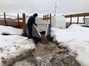
Crop rotation is paired each year with winter wheat, spring wheat, spring canola, garbanzo beans, and winter peas commonly grown. To document the impacts of these two management treatments on water, two isolated, 30-acre catchments have been instrumented with paired flumes that monitor both surface runoff and subsurface flow from artificial drain lines within each field. Each flume is also equipped with automated water samplers that collect water samples throughout storm events, which are then analyzed for sediment, nitrate, and dissolved and particulate phosphorus concentration. These instruments provide all the necessary information to record the total losses from each field. With this instrumentation, scientists were recently able to document one of the most severe frozen soil runoff and erosion events that the region has experienced over the last 30 years. 
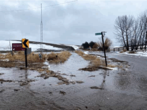
The frozen soil runoff storm event occurred on Feb. 23 and Feb. 24 this winter. This event was set up by cold, dry, conditions in January. There was little to no snow cover to insulate the soil across the region when nighttime temperatures dropped below 20 F over a two-week period. Overnight temperatures dropped down to -14 F in Moscow, Idaho, on Feb. 12. By mid-February, the soil was frozen down to 6 inches in Moscow. In the weeks prior to the snowmelt event, 7-10 inches of snow accumulated over the frozen soil in the Moscow Pullman area. Warming temperature starting on Feb. 22 and over 1.5 inches of rainfall lead to one of the largest flood events in the last 30 years in Moscow. The combination of 1.5 inches of rainfall with 1-2 inches of water melted from the snowpack over frozen soil that was largely impermeable to water was the perfect conditions for an extreme runoff and erosion event. 
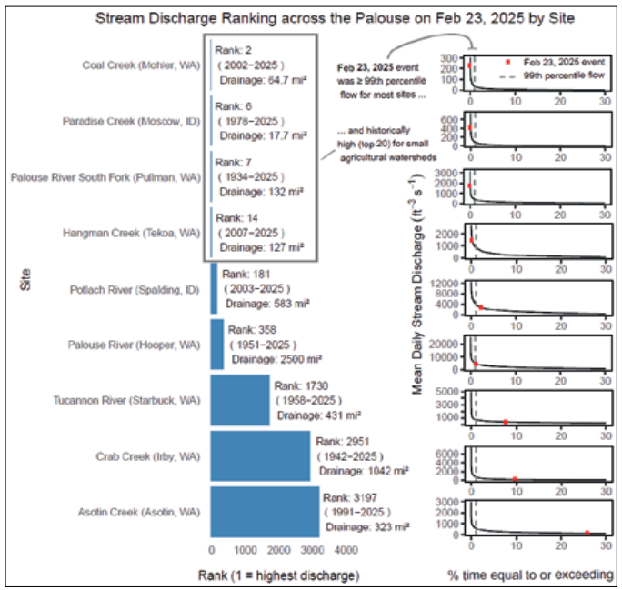
Stream flow records from nine U.S. Geological Survey-monitored streams across the Palouse (see Figure 1 on previous page) show that flow on Feb. 23 was historically high (top 20) for relatively small
agricultural watersheds draining less than 132 square miles and was 99th percentile or greater for most of the surveyed streams. For example, Coal Creek in Mohler, Wash., had the second highest discharge on that day since 2002, whereas the Palouse River had the seventh highest record since 1934. Thus, the historically high water flow across the Palouse’s agriculturally dominated landscape would have created ideal conditions for a powerful erosion event around Feb. 23.
Preliminary data collected during this event indicates that although similar amounts of runoff were experienced from both watersheds at CAF, the continuous no-till management experienced less soil loss as surface residue cover on the ground held the soil.
More resources on managing soil erosion in Eastern Washington were compiled by the Washington Soil Health Initiative and are available at soilhealth.wsu.edu/erosion/